
FAQs
I just tried your proximity locator. How do you know how far away I am from all these earthquakes?
Last updated 2019-01-17
Answers to general inquiries, basic knowledge and earthquake 101.
I just tried your proximity locator. How do you know how far away I am from all these earthquakes?
2019-01-08
First, we convert your geographic location (or your address) to latitude and longitude world coordinates. There is also a very obvious difference between "transport distance" and the shortest distance between two points (as the crow flies). Mapping software will usually return the transport distance, which is only a secondary consideration, and it's not the direct distance between you and an earthquake.
There are two and three dimensions to consider.
Let's work with X (latitude) and Y (longitude), and remove Z (height and depth) variations.
Now we have 2 surface points to calculate the distance.
Your proximity to the surface epicenter of an earthquake is always a direct line - even if it goes through a mountain.
However, the curvature of the earth complicates the math, and the line is not exactly straight.
There is an increasing arc across greater distances.
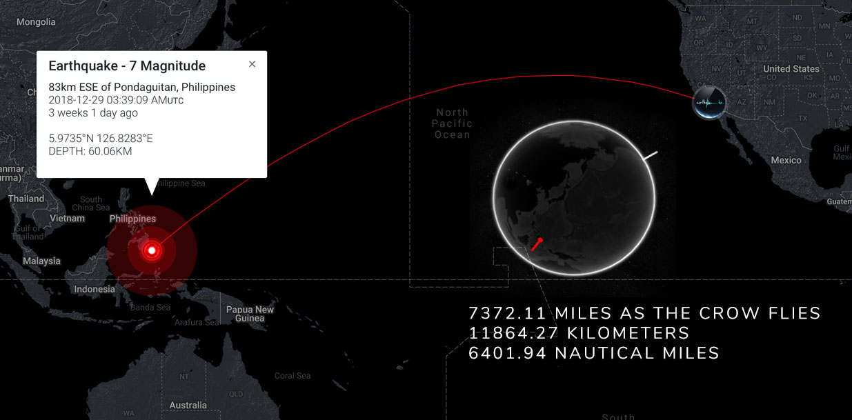
Here is an example of how a "straight" line (from the intersection at Hollywood Blvd and Vine Street in Los Angeles ) appears to arc to the coordinates of an earthquake in the Philippines. The globe displays one pin in each location, and the map displays the shortest path between them in 2 dimensions.
It becomes further complicated when you consider "the globe" is not a perfect sphere. The Earth slightly bulges at the equator. And, the precise location of an earthquake also has some variance and degree of error - especially at sea.
There are mathematical formula(s) for calculating almost exact distance between two points on the globe - without relying on satellite mapping (which can get expensive!). Using both sets of world coordinates, we perform this calculation in a split second to display your surface distance and proximity to an earthquake.
When you log in, you will instantly see your proximity to the largest and most recent nearby earthquakes.
If you double-check the accuracy, it's pretty staggering.

There are two and three dimensions to consider.
Let's work with X (latitude) and Y (longitude), and remove Z (height and depth) variations.
Now we have 2 surface points to calculate the distance.
Your proximity to the surface epicenter of an earthquake is always a direct line - even if it goes through a mountain.
However, the curvature of the earth complicates the math, and the line is not exactly straight.
There is an increasing arc across greater distances.
Here is an example of how a "straight" line (from the intersection at Hollywood Blvd and Vine Street in Los Angeles ) appears to arc to the coordinates of an earthquake in the Philippines. The globe displays one pin in each location, and the map displays the shortest path between them in 2 dimensions.
It becomes further complicated when you consider "the globe" is not a perfect sphere. The Earth slightly bulges at the equator. And, the precise location of an earthquake also has some variance and degree of error - especially at sea.
There are mathematical formula(s) for calculating almost exact distance between two points on the globe - without relying on satellite mapping (which can get expensive!). Using both sets of world coordinates, we perform this calculation in a split second to display your surface distance and proximity to an earthquake.
When you log in, you will instantly see your proximity to the largest and most recent nearby earthquakes.
If you double-check the accuracy, it's pretty staggering.
Do you have an earthquake app with push notifications?
2019-01-07
We unofficially opened for public preview on 2019.01.01.
Joining will commence some time in Q1, at which time our advanced features will be available to registered members.
Three of these features include geolocation services - with push notifications - single-click responses, and the creation of groups.
When every member logs in, those who specify a private address on their profile will instantly be shown:
• The nearest recent earthquake to them, and relevant data about it.
• Their distance to the strongest earthquakes within 100/300 and 1000 KM, and relevant data about them.
• Distance to the "the last big one" that occurred on planet Earth.
• A link to "all earthquakes nearby" within their selected range - this hour, today, this week and this month.
• Selectable preferences to accept push notifications by SMS text and/or email for any earthquake (M5+) within a certain range.
• A private list of friends or family can be created to notify them (or be notified) of any significant earthquake they may be affected by.
All features already function like an "app". The website interface allows you to conveniently do the same thing, but it also allows guests and UN-registered visitors to try it out without joining at all. The primary importance is to make certain features, materials and information available for everyone on the planet with an internet connection. This includes non-members who need surface-level information, and not just those who already actively participate.
As it stands, most people generally go about their daily lives giving little thought to preparing for "the next big one" (or any unexpected emergency) in their lives. They tend to take more of an interest AFTER it occurs, and even then, only if they are somehow negatively affected by it.
The first maxim of business: "It doesn't matter what you're selling. It only matters what people will buy".
So if someone wants to get an "earthquake preparation app" out there into as many hands as possible, they may have to market it as . . . a foot massager.
If you figure out how to do this, please let us know.
To more succinctly answer your question: Baby steps. We're working on it.
What about time zone differences when earthquakes occur?
2019-01-06
An earthquake occurring anywhere in the world is marked with a timestamp. The UTC timestamp is the same no matter in which timezone you are located. An earthquake happening in Japan "right now" is also happening "right now" anywhere else. The only difference is . . . "right now" may be noon in Japan, but in Los Angeles, "noon" is 17 hours later. Similarly, while people in Japan may be tweeting about an earthquake that happened "5 minutes ago", Americans do not need to wait 17 hours to hear about it. It still happened "5 minutes ago" no matter where you are in the world.
The human readable date/time of an earthquake is reported in UTC - which is the more-widely used scientific replacement for GMT (Greenwich Mean Time). UTC is the time standard commonly used across the world. The world's timing centers have agreed to keep their time scales closely synchronized ( and coordinated ) hence the name "Coordinated Universal Time".. Simply put, GMT is a time zone, and UTC is a time standard.
Examples:
Eastern Standard time in the U.S (i.e New York) is UTC - 5 hours.
UTC - 4h during daylight savings time.
Central time in the U.S (i.e Chicago) is UTC - 6 hours.
UTC - 5h during daylight savings time.
Coordinated Universal Time is 8 hours ahead of Pacific Time.
6:33 PM Thursday, Pacific Time (PT) = 2:33 AM Friday, Coordinated Universal Time (UTC)
To continually perform the math in your head can get confusing, so we convert the time of occurrence to local time for our members. We also convert the timestamp to "friendly time ago". So, whatever the actual UTC timestamp may be, "friendly time ago" tells you the earthquake happened "this long ago" in readable English. Further calculation is then performed to convert that timestamp programmatically to your local time. The UTC timestamp is always the same for us, but your web browser knows what the local time is for you. We send the timestamp to the webpage you're looking at, and your browser will convert it. Additionally, when serving maps with latitude and longitude coordinates for earthquakes, the maps API can make a quick calculation relative to UTC, and display the local time of the occurrence.
Who created the earthquake.co logo? It’s perfect.
2019-01-05
Our logo was conceived and designed on a cocktail napkin. While doodling the word "earthquake" with a pen, a waiter dropped his tray and made a startling sound that turned everyone's head. The resulting scribble coincidentally resembled a seismographic design, and we just elaborated on it. We tried various incarnations with target symbols, techy HUD graphics (heads-up display), and some incorporation of an Earth icon . . . but we kept reverting to the original.
Occam's razor implies: "the simplest solution is usually the correct one".
It suggests someone wrote the word "earthquake" . . . then an earthquake occurred . . . and after a brief pause, the word resumes.
The hand-written letters add a human element.
The accompanying tagline "what's shaking?" is an informal and familiar way of greeting someone.
But in this context, it can now be taken literally.
Thank you for noticing!
Are you planning on offering any merch? I want a T-shirt!
2019-01-02
You mean merchandise?
How's this for a teaser . . . .
How's this for a teaser . . . .
What was the biggest earthquake ever recorded?
2019-01-01
The world's strongest earthquake (with an instrumentally documented magnitude) occurred on May 22, 1960 near Valdivia, in southern Chile. It was assigned a magnitude of 9.5 by the United States Geological Survey. It is referred to as the "Great Chilean Earthquake" and the "1960 Valdivia Earthquake". The earthquake occurred on a fault that is almost 1,000 miles long. A "mega-quake" in its own right.
California is often referred to as "earthquake country" with dozens of minor earthquakes occurring every week. The San Andreas fault is only 800 miles long, so it has been said an 8+ would be unlikely in California. No fault long enough to generate a magnitude 10 earthquake is known to exist. If it did, it would extend around most of the planet. However, if a large celestial object were to crash into Earth, a 10+ "earthquake" could certainly occur that way. While there can be no official ceiling on the possible magnitude of an earthquake, no magnitude 10 (or greater) earthquake has ever been observed.
The 6 strongest earthquakes ever recorded:
m9.5 - Valdivia, Chile, 22 May 1960
m9.2 - Prince William Sound, Alaska, 28 March 1964
m9.1 - Sumatra, Indonesia, 26 December 2004
m9.0 - Sendai, Japan, 11 March 2011
m9.0 - Kamchatka, Russia, 4 November 1952
m8.8 - Bio-bio, Chile, 27 February 2010
Still have questions? Feel free to contact us anytime.